Washington Court House Bike Path and the Birth of Fayette Citizens League


Hello, everyone!

This is our inaugural newsletter, and we have a lot to discuss. Our primary focus will be providing both new and existing information about the project aimed at addressing the bike and pedestrian traffic issues that have emerged in Washington Court House over the past few years. The story behind this project is quite fascinating when presented as a timeline – and more surprising than you can imagine. 


The image below provides a brief overview of this newsletter, which is perfect if you don't have the time to read everything right now.


Pedaling to the starting line

This entire story began when a group of concerned citizens noticed heavy pedestrian and cyclist traffic at the road and intersection behind Kroger. This area was frequented by seniors and children on mobility scooters and bicycles, often sharing the road with a significant number of cars and trucks, some of which were speeding dangerously around the corner. Not to mention there is also 2 train tracks intersecting with the road.

Recognizing the danger, we decided to take action and approached the city to request the construction of a bike path that would provide a safer alternative route to this side of town.


Map Mayhem

A citizens' group presented a map to the City Council addressing safety concerns and pedestrian crossings at the busy intersection. Although the council initially hesitated, they later embraced the idea and were prepared to proceed with it at the next meeting.


The first map presented by our group proposed a shorter route achievable with minimal intervention, including paint and a small metal or concrete divider to protect bikers, with estimated costs maxing out at $50,000 per mile. While this may initially seem like a substantial amount, the actual cost is expected to be lower, making the city's offer less favorable.

After months of apparent deliberation from the city, they began stating that they were waiting for a engineering firm to survey and engineer a map. After our group repeatedly requested updates, they provided a map that that was not created by an engineering firm that detailed a new route.


The concern with this map was that, while it offered a more detailed layout, it required the purchase of easements from local property owners, including the larger property owned by Judy Patterson, which the city had been eyeing for other improvements.


Both maps have their pros and cons. However, the current plan is to combine the two by implementing the older map first, which comes at a lower cost, and later extending part of the trail to connect to Cherry Hill School, as the city had originally intended. This approach prioritizes addressing the public safety issue without sacrificing the shorter-term timeline for the more ambitious trail.


We asked the city about their timeline for implementing this plan.  To our surprise, they did not provide a specific timeline but stated that they would complete the trail in sections, beginning from Lakeview Ave and moving south along the Patterson property for their first phase. However, we believed it was more crucial to commence from Kroger due to the safety concerns at Veteran's Way. After a planning discussion, the city agreed to our proposal.

Property Problems

Sidenote: (Judy Patterson initially hesitated to sell her property to the city due to several concerns. Our group and other friends of Judy eventually reached a deal with her and facilitated the sale of the land to the city.)


This leads us to our next topic: what happened when the city finally responded. After several months passed with no updates, the city suddenly announced that they would meet with engineers to begin construction from Lakeview, using a map from the engineering firm they had hired.


What's surprising about this map is how the communication between the city and the citizens group must have broken down. This map is exclusive to the Patterson Property and does not connect to the main road or even a proposed trail in any way. The city has not provided clear explanations for the circumstances that led to such a map being created and presented. It was indeed a shock and caused a delay of several months in our progress.


After numerous concerns about the inconsistency of this plan with its intended goal, we requested the city to reconsider the map and offered an alternative solution that could address two issues at once. Our suggestion was to install only the eastern side of this trail leading south. The budget saved from this adjustment could then be allocated for the installation of a drainage system, a concern that community members had brought to the city's attention but had not yet been addressed.


The city did go through with a rough trail on the east side of the Patterson property made of crushed asphalt, it was not extended to Lakeview Ave.

Conflicting Grant Appropriations

You may have a few questions at this point, and we will attempt to address as many as possible in this newsletter. If we haven't covered everything, please remember that you can always email us at fayettecitizensleague@gmail.com.

If you have questions regarding the funding for this project, we will try to answer them here.


Q: How much did the city allocate for this?

A: The city has mentioned on multiple occasions that they initially set aside a budget of around $240,000 for the initial proposal. If budgeted correctly, this amount should have been more than sufficient. With the city's additional designs, there is a theory that it may not be enough, but this remains unknown at this time.

Q: Could the city obtain any grants to assist with this project?


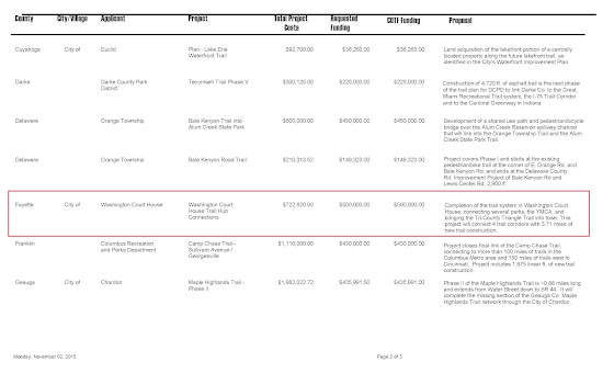
A: Yes, indeed! The city had access to a $500,000 ODNR grant for trails and parks. Unfortunately, they failed to utilize it, and the ODNR rescinded the grant after 7 years of no action! Although the original grant was not specifically for this project, the city had the opportunity to reapply and include this project but missed the deadline this past April.


Q: What is the remaining budget as of October 2023?

A: The exact figure is unknown, as the city hasn't provided a comprehensive response when asked. There has been a debate about the 900ft paved area at the sewer plant (our next topic) being included in the budget for the specific trail we have requested. The city has stated it is in a separate grant but has not provided any budget information to confirm this.


This sheet from the ODNR show the grant that the city received in 2015 for trail improvements and extensions.


Sewer Trails

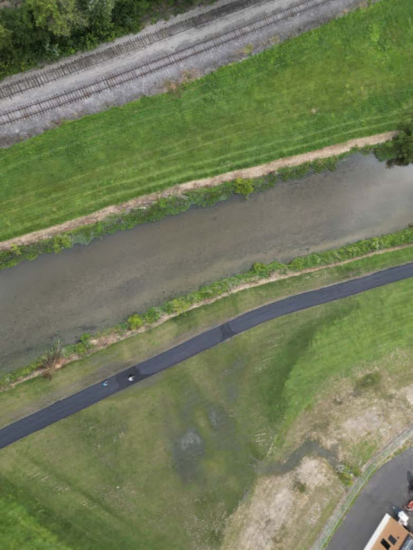
Last year, the city closed the sewer plant section of the trail for a period. The city stated that they were going to install a pipe to manage water runoff. However, when it was reopened, members of the Triangle Trail(the non-profit organization responsible for trails in the tri county area) noticed that the city did not install a drainage system. Instead, they lowered the ground near the river, for approximately 100 feet of the trail, which would increase the risk of flooding on the trail, which already floods two to three times a year on average.


When this issue was brought to the city's attention, they assured us that it would be fixed. However, as of this newsletter, no action has been taken. This brings us to early September of this year.


We discovered that the city had started paving a 900-foot trail behind the sewer plant. Initially, we didn't think much of it, but after the paving was completed, someone noticed water coming out of a pipe and spilling onto the trail due to the lack of drainage. This created an unpleasant odor and posed a slipping hazard for pedestrians and cyclists. Concerned that this unrelated trail might be diverting funds from the main bike trail, we sought information from the city. The city manager stated that it was funded by a separate grant but has not provided details about the grant's source despite multiple inquiries over the past three weeks.


In this video it was stated that it was grant funded.


In this video it is stated there was in fact not a grant


A Persistent Issue

Despite this issue being brought to the attention of the city council in early August of 2022, with the city stating they would resolve the public safety issue and construct these trails, we have seen nothing completed except for a small, unfinished gravel trail(Patterson property), and a perplexing and wasteful allocation of the trail budget(tax dollars) over at the sewer plant section, over the past 13 months. We understand the complexities of city planning, traffic engineering, and more, but larger cities have successfully implemented bike lanes in less time, even with much larger distances to cover.


What are your thoughts on the data we've provided so far? We hope this has offered insight into our progress.


Please remember to email us if you would like to ask questions or contribute.

fayettecitizensleague@gmail.com.


If you would like to sign for future newsletters, if you already have not please fill out our short survey.

Sign Up for Newsletter

Comments